


YellowScan launches its new Terrain module

Add-on for the YellowScan CloudStation suite improves accuracy and ease of use for point cloud rendering
YellowScan, a global leader and designer of next generation of UAV LIDAR solutions, announces the immediate availability of its new software add-on module: Terrain.
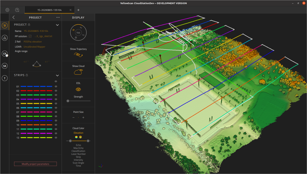
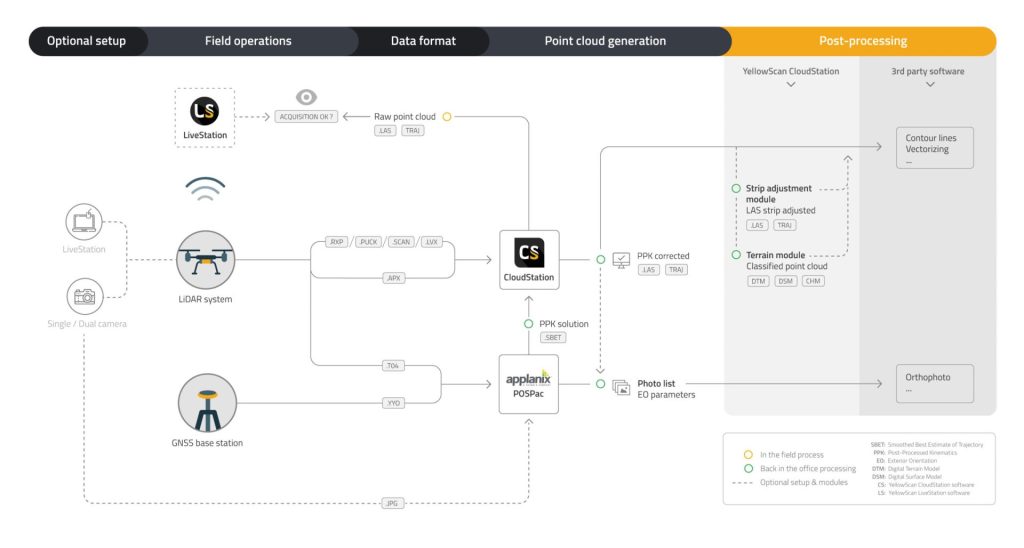
This new module enhances the processing power of CloudStation, YellowScan’s powerful data processing tool that provides users the ability to create and manipulate point cloud data from their LiDAR mission’s. It enables you to extract, process and display data immediately after acquisition, giving you the ability to program the auto-generation of flight lines and export .LAS files in just a few clicks.
The surveyor can also visualize the result of the classification and select which classification class to visualize (unclassified, ground, other).
The new Terrain module simplifies the experience for customers to extract classified point cloud, making it easier to process flight data and save time. The key business benefits are the following:
A simplified classification process
The addition of Terrain increases the effectiveness of CloudStation by allowing for the automatic classification of points as “ground/non-ground”. This enables the user to select a “preset profile” based on the type of terrain the YellowScan LiDAR solution is being flown in such as mountain, forest, or cliff.
A data extraction made in just 1 click!
Terrain offers several additional export format types of data. The user can export classified LAS or digital models such as DSM (Digital Surface Model), DTM (Digital Terrain Model) and DHM (Digital Height Model) as GeoTIFF (geolocalized TIFF).
This new module will allow CloudStation to generate a hillshade for your Digital Terrain Model (DTM), making it easier to visualize and better understand the level of detail you can observe from your flight data.
“The Terrain module was developed to answer our customer’s needs to have a tool that can easily and automatically classify LiDAR point cloud and generate bare earth models” stated Tristan Allouis, Chief Technical officer of YellowScan. Petter Hoffmann from Trimtec added “The Terrian module is working quite smooth, helping process data in the field fairly quickly thus giving our team more time to analysis the output and counsel our customers”.
About YellowScan
At YellowScan we design, develop, and build our UAV LiDAR solutions to exceed the expectations of professionals that require performance, robustness, and accuracy. Our complete hardware and software solutions are easy to use data collection tools coming with an unparalleled level of training and support from our experts.
Founded in 2012, YellowScan has customers around the world, and its products are used in surveying, forestry, environmental research, archaeology, industrial inspection, civil engineering, and mining sectors. Our innovative LiDAR solutions are complete hardware and software platforms, easy to use data collection tools combined with an unparalleled level of training and support from our experts.
For more information, please visit www.yellowscan.com.
Contact
Morgane Selve, Communications Manager at YellowScan
Direct Line: +33 4 11 93 14 23 – press@yellowscan-lidar.com